


Anyone who has tried to use Google Maps to navigate the London Underground at rush hour, or worked out which subway car puts you closest to the right exit at Union Square, knows the limitation. Google Maps is a generalist; it has to serve drivers, walkers, and cyclists in suburbs and small towns as well as in megacities. In dense urban transit networks, that generalist focus shows.
Citymapper, by contrast, was built specifically for the kind of person who has stood on a London bus stop trying to figure out whether it’s faster to wait for the 38 or walk to Oxford Circus and take the Victoria line.
Citymapper launched in London in 2011, expanded across Europe, North America, and Asia, and joined NYC-based mobility tech company Via Transportation in March 2023. Via later went public on the NYSE in September 2025 with a $3.65 billion valuation.
The app now covers public transit in 400+ major cities globally, with more than 50 million users having planned journeys on the platform.
Below: how it works, what’s free vs paid, how it compares to Google Maps and Waze, and the recent changes worth knowing about.
Introducing Citymapper: The Public Transit App That Quietly Beats Google Maps in the City
Citymapper was founded in 2011 by Azmat Yusuf, a former Google employee who got the idea while struggling to navigate London’s bus network on his commute. The company launched with zero marketing budget and grew almost entirely through word-of-mouth in London before expanding to New York, Paris, Berlin, Tokyo, and beyond. By 2023, the app covered over 100 cities and had attracted a loyal user base of 50+ million riders.
In March 2023, Via Transportation acquired Citymapper for $73.9 million — a deal widely described as a “fire sale” given Citymapper’s earlier failed attempts at monetization (a paid bus service, a multi-transport subscription called Citymapper Pass). Via was already building software for cities and transit agencies;
Citymapper became the consumer-facing front-end of that system. Following the acquisition, Via made a significant change: it removed Citymapper’s premium feature paywall, making all previously gated features (lock-screen navigation, bus-only routes, turn-by-turn voice navigation, real-time alerts) free for everyone. The only thing you now pay for is ad removal.
Via itself went public on the NYSE in September 2025 under the ticker $VIA at a $3.65 billion valuation, raising $493 million in the offering. The company operates across 650+ cities and 30 countries through its broader transit platform; Citymapper continues as the standalone consumer app, with the technology now integrated into city-level deployments like Transport for West Midlands’ regional journey planning (rolled out March 2026).
How Does Citymapper Work?
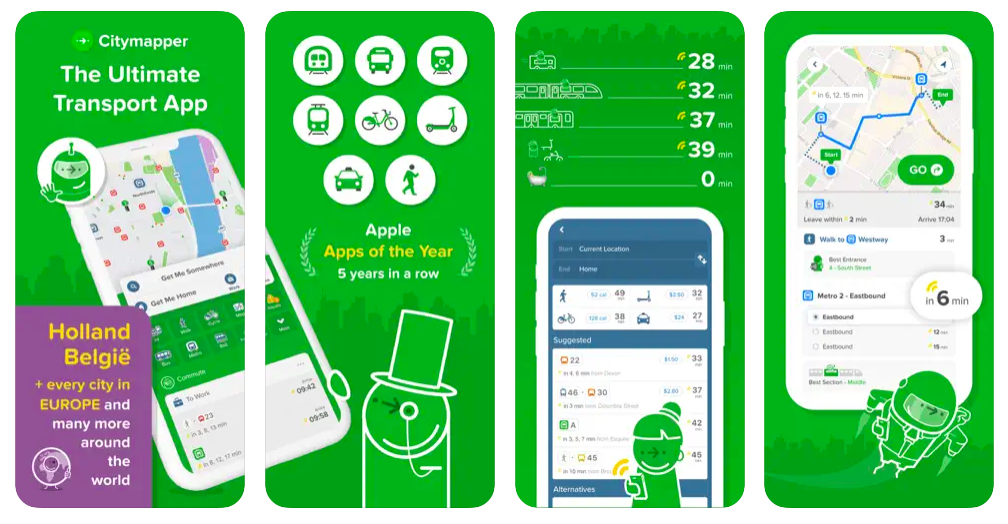
Citymapper is built around a single screen: enter a destination, get every possible way to get there ranked by time, cost, and convenience. The app aggregates data from public transit agencies (in London alone: TfL, Underground, Overground, DLR, Tramlink), private operators (National Rail, Arriva, Stagecoach, First Bus), shared mobility partners (Uber, FREENOW, Gett, Lime, Forest, Beryl, Santander Cycles, Zipcar, Getaround), and ride-hail services into a unified routing engine.
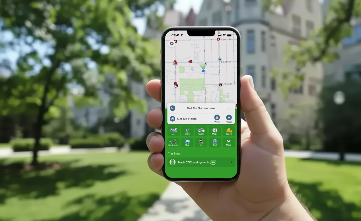
Open the app and you’ll see two large action buttons: “Get Me Somewhere” and “Get Me Home” (your home and work addresses are saved separately and accessible from the home screen). Below them, the transport modes you can filter by:
- Walk
- Cycle (including bike-share availability at nearby stations)
- Bus
- Tram
- Rail (Underground, Overground, regional rail)
- E-scooter
- Cabs (with live Uber/FREENOW/Gett fare comparisons)
- Carshare (Zipcar, Getaround)
Enter your destination and Citymapper returns every plausible route, ranked by total journey time, with the live cost displayed alongside each option. The depth is what makes the app indispensable in big cities. Beyond the basic route comparison, Citymapper includes:
- Walk less — Prioritizes routes with minimal walking. Useful on rainy days, when you’re injured, traveling with kids, or carrying luggage
- Simple route — The option with the fewest transfers
- Turbo — The fastest possible route regardless of cost
- Rain-safe route — When it’s raining, the app suggests routes with maximum coverage
- Optimal subway car — In NYC and London, the app tells you which carriage of the train to board for the fastest exit at your destination station. This is the feature people rave about.
- Live delay alerts — Subscribe to specific lines and get push notifications about disruptions
- Live trip sharing — Send friends a link so they can track your arrival in real time
- Offline transit maps — Download the TfL Underground map, the West Midlands network, and others for offline use
- Calories and CO2 tracking — Shows you what you’ve burned walking or cycling and how much CO2 you’ve saved versus driving
For a broader view of mapping options beyond just transit, our guide to the best Google Maps alternatives for navigation covers Waze, HERE WeGo, Apple Maps, MapQuest, and others — including which app shines in which scenario.
Citymapper Pricing: Is It Really Free?
Yes, almost entirely. The core Citymapper app — including every routing feature, real-time alerts, offline maps, and live tracking — is completely free. This was not always the case. Between September 2022 and May 2023, Citymapper Club was a paid subscription that locked features like bus-only routes and turn-by-turn voice navigation behind a $2.99/month paywall. After Via’s acquisition in March 2023, the company lowered the paywall, making all premium features free.
What you can still pay for, optionally, is ad removal:
- $1.49 / £1.49 per month
- $9.99 / £9.99 per year (~$0.83/month if you commit annually)
The ad-free upgrade is the only Citymapper subscription that exists today. It exists primarily to give the company a small recurring revenue stream while keeping the core product free. For most users, the ads are unobtrusive enough that paying for ad-free isn’t necessary; for daily commuters who open the app 10+ times a day, the annual fee is roughly the cost of one cup of coffee per month and may be worth it.
The honest pricing context: Citymapper is one of the genuinely free travel apps. There’s no Premium tier locking the good features, no in-app purchases, no required account upgrade. Just an optional ad-removal subscription, and everything else included.
Citymapper App Reviews & Ratings: How Well Does It Work?
The mobile app store ratings tell one very clear story:
- App Store: 4.9 / 5 (102,000+ reviews)
- Google Play: 4.8 / 5 (368,000+ reviews)
Across nearly half a million reviews combined, Citymapper is one of the highest-rated travel apps on either platform. Reviewers consistently praise the routing accuracy in major cities (London, New York, Paris, Berlin), the depth of mode integration, the live delay alerts, and the small touches of personality in the UI (the app famously offers “jetpack” and “teleportation” as joke transport options).
Worth noting honestly: Citymapper’s Trustpilot score is 2.7 / 5 on a much smaller base of around 60 reviews, with most one-star ratings coming from users frustrated about the old paywalled features, the Citymapper Pass (a discontinued multi-transport subscription that some reviewers report charged them incorrectly), or accuracy complaints outside the app’s strongest cities.
The discrepancy between the app store scores and Trustpilot reflects the difference between casual users (who write quick app store reviews when an app is consistently useful) and unhappy customers (who go to Trustpilot specifically when something has gone wrong). For a more accurate picture, the app store ratings — based on hundreds of thousands of reviews from active users — are the better signal.
Reviewers tend to draw a sharp distinction between cities where Citymapper truly excels and cities where it’s weaker. London, New York, Paris, Berlin, Edinburgh, Manchester, and Tokyo consistently get praise; smaller European cities and parts of Asia get more mixed reviews about timetable accuracy. If you live in or regularly visit a major metropolitan transit network, Citymapper is generally a meaningful upgrade over Google Maps. If you’re in a small town or a city Citymapper doesn’t fully support, Google Maps’ broader coverage wins.
One representative Google Play review from Emily Carter captures what frequent users tend to value: “The best app. It gives me so much more confidence navigating cities as a solo female traveler. I especially appreciate the main road options and the costs being posted, so you can stay on budget. It’s rarely wrong.”
Citymapper Alternatives? Waze for Driving, Transit for North America
Waze remains the answer for driving, not public transit. It’s a community-powered navigation app where users (called “Wazers”) report police speed traps, accidents, road closures, and traffic in real time.
At the start of a journey, Waze presents options for the fastest, most fuel-efficient, and shortest routes, all updated continuously based on community data. For driving in cities with active Waze communities (most of the US, much of Europe), it consistently beats Google Maps on traffic accuracy. For public transit, it does nothing — that’s not what it’s built for.
Transit (the app from Montreal-based startup Transit) is Citymapper’s closest direct competitor and arguably the better option in many North American cities. It launched earlier (2012), has stronger coverage in mid-size US cities (Denver, St. Louis, Minneapolis, Buffalo, etc.) where Citymapper is thin, and offers free Premium memberships in partnership with some transit agencies.
If you’re in a North American city Citymapper covers (NYC, Chicago, LA, Boston, DC, San Francisco), Citymapper is usually better; outside those, Transit often is.
Google Maps and Apple Maps are the default fallbacks. Google Maps’ transit coverage has improved significantly in recent years, and in cities Citymapper doesn’t cover well, Google is often the right call. Apple Maps remains weakest of the three for public transit but has improved notably in major metros.
What we at LocalsInsider.com think:
Citymapper is the best public-transit-first app on the market in the cities it covers well — London, New York, Paris, Berlin, Tokyo, and roughly the 20 other major metros where it’s invested deeply. Waze is the best community-powered driving app.
Google Maps is the best generalist. Transit is the best alternative for many North American mid-size cities. The right choice depends on the city and the trip, and for most travelers, having all three (Citymapper, Waze, Google Maps) installed is the smart approach — each does one thing better than the others.